Explor eliminates seismic lines in the oil sands, sets new seismic trace density record

PinPoint seismic method eliminates environmental footprint and associated impacts on caribou while enabling Ultra-High Density seismic imaging of oil sands targets
CALGARY, May 31, 2018 /CNW/ - Explor Geophysical Ltd. ("Explor") has completed the first pre-commercial scale Ultra High Density (UHD) 3C 3D seismic survey using its PinPoint technology, confirming the viability of seismic acquisition without seismic lines.
Over a small area, Explor acquired seismic data at a density of 100 million traces per km2 at full offset, with trace densities > 42 million traces per km2 at target depth.
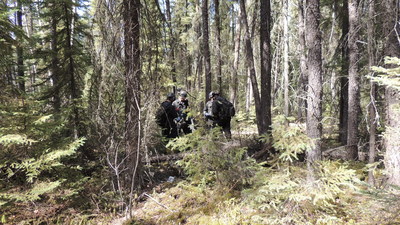
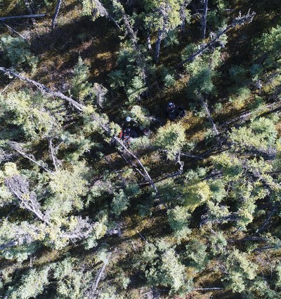

In sharp contrast to standard 'low-impact seismic' (LIS) methods, these data were acquired without preparing any lines or trails and without cutting down any trees or a single stem of vegetation, setting a new standard for seismic acquisition in the oil sands. While typical 'low impact' seismic projects in the oil sands region mulch 2.75-metre-wide seismic lines spaced 30 to 80 metres apart to accommodate equipment, the PinPoint method does not require seismic line preparation.
Over the last two decades, the seismic industry has worked to reduce seismic line widths from conventional widths of 6 to 8 metres to current low-impact widths of 1.75 metres and 2.75 metres in the oil sands. While intended to minimize the use of lines by wolves and the associated increase to depredation of boreal woodland caribou, recent research has shown that wolves still use even the narrowest mulched lines. Thus, the most widely adopted mitigation measure to reduce environmental impacts associated with seismic lines - cutting narrower seismic lines - does not fully meet a key objective for caribou conservation.
"Typical low-impact seismic operations in the oil sands can directly remove up to 15% of forest cover, and seismic lines alone can account for over half of the total disturbance footprint associated with SAGD operations. We know that simply cutting narrower lines doesn't adequately achieve conservation goals for caribou, and more and more research is showing that even LIS lines impacts a range of ecological values in undesirable ways, especially so at the very high line densities required for oil sands operations. It's exciting to help develop a new technology that eliminates the seismic footprint and associated impacts to more fully meet conservation goals while delivering exceptional seismic data quality." – Jesse Tigner, Senior Ecologist, Explor
The Alberta Energy Regulator granted approval to test the PinPoint method through a riparian area where other seismic sources are not permitted, eliminating key gaps in seismic data coverage. This enhances imaging of caprock and reservoir attributes, key deliverables of seismic imaging for SAGD projects.
"The relationship between traditional low-impact seismic lines and boreal woodland caribou is a major focus for regulators and represents a key business risk for oil sands operators. Achieving this transformational outcome with PinPoint eliminates this business risk for our oil sands clients. Completing the project outside the traditional winter operating season confirms the viability of immediately transitioning to full commercial scale for year-round, zero impact, ultra-high density seismic data acquisition. The development and commercialization trajectory for PinPoint is among the most exciting things I've seen in my 30 year career." - Allan Châtenay, President, Explor
Explor was able to acquire the data outside the traditional winter operating season for seismic acquisition in the boreal forest, creating the potential for year-round zero footprint operations. Year-round operations represent a profound shift in the business model for the Canadian seismic industry, an industry sector that has seen major challenges during recent years.
About Explor:
Explor is a privately held Canadian company that acquires high quality geophysical data with minimal environmental impact. Explor employs a team of qualified scientists across a range of scientific disciplines as well as project teams and logistics experts to accomplish its objectives through a rigorous continuous improvement process. Explor specializes in challenging and extraordinary projects.
These PinPoint tests follow a series of 3D projects in the greater Montney play fairway in which Explor pioneered the elimination of receiver line clearing, became the first company to do Independent Simultaneous Shooting with Nodes (ISSN™) in Canada and demonstrated the value of high trace densities by attaining 1.25 million to over 5 million traces per square kilometer, successfully imaging previously unseen geological features while reducing environmental impact.
If you would like more information about this topic, please contact Allan Châtenay at 403-263-5950 or email at [email protected]. Explor can also be found at www.explor.net and on YouTube, Twitter and Facebook.
SOURCE Explor

Allan Châtenay, Telephone 403-263-5950, Email [email protected], Website www.explor.net
Share this article